Our Research
i. Monitoring coastal cliff erosion
A key focus of the COBRA project from the outset has been monitoring coastal cliff erosion along the North Yorkshire coast. Previously there had been much uncertainty regarding the rates of cliff erosion and how this varied alongshore. Using photogrammetry and both ground-based (terrestrial laser scanning, TLS) and aerial-based laser scanning (light detection and ranging, LiDAR) we are able to monitor erosion of the cliffs at high temporal and spatial resolution. Throughout the duration of the project we have developed the application of these techniques and newer technology to obtain increasingly higher resolution and accurate calculations of cliff erosion rates. This approach provides a much more detailed picture of how, when and where the cliff face fails as compared to more conventional approaches and has provided significant insight into the failure characteristics of hard rock cliffs. This dataset has raised research questions which we address with much of our subsequent research.
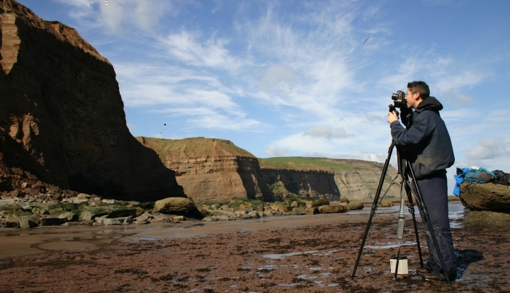
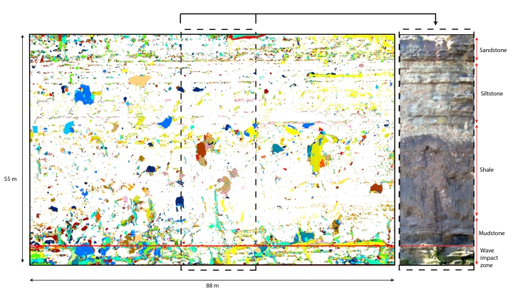
Using photogrammetry to monitor coastal cliff erosion. Successive sets of photographs can be used to determine changes in the geometry of cliff race that result from rockfall activity.
This figure shows an example of erosion recorded from a section of the monitored cliff face over a two-year period. The colours represent rockfalls captured in different months. Using this data we have shown that these cliffs behave very differently to how traditional models would suggest, where erosion is said to occur largely at the toe, driven primarily by wave action.
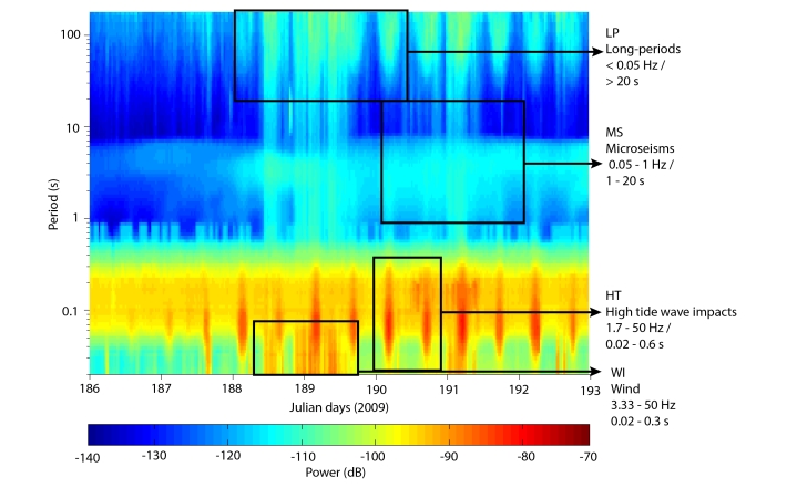
ii. Relationships between cliff rockfalls and marine and weather conditions
The results of our cliff erosion monitoring raise questions around what controls the pattern of rockfall over time and through space. To constrain the environmental controls on rockfall and erosion we have assessed the relationship between rockfall and locally measured weather and nearshore sea-state conditions. Such relationships are invariably weak, most probably because the conditions at the cliff face are highly variable and locally specific. We have focussed on developing approaches to monitor conditions directly at the cliff face, overcoming the problems of access and instrumentation robustness in such a dynamic environment by monitoring the microseismic ground motions caused by winds, waves and tides.
We have characterised four frequency bands of cliff microseismic motions that represent different marine/wind conditions, shown in the figure opposite: Long-period (LP) motions are generated by long-period ocean waves and tides that cause tilt of the cliff; Microseisms (MS) are cliff motions generated by the pressures that build beneath waves as they propagate through deep to shallow water; High tide wave impacts (HT), triggered by direct wave action on the cliff face; and Winds (WI) driven by buffeting against the cliff face and cliff top, driving higher frequency shaking.
iii. Laboratory modelling of rock failure
A central theme in our research focuses upon the role of material control and deformation on rock failure, in the context of both cliff slope failure and in deep underground settings. The Department of Geography Laithwaite Landslide Laboratory has been specifically designed to allow bespoke characterisation of rock strength at stresses commensurate with those found in the cliffs on the North Yorkshire coast, and also at depth within the Boulby Mine itself. Our testing facilities also include the ability to simulate the temperatures found at depth. For weaker materials, such as the glacial tills encountered in the COBRA study area, we use standard triaxial testing and our back-pressured shearbox, which allows direct exploration of the relationship between pore water pressure and landslide movement. Much of our geotechnical testing equipment has been developed in collaboration with GDS Instruments.
iv. Wide-area ground deformation
We are interested in both natural and man-made influences on wide-area ground deformation. This includes the influences of historic extraction of foreshore rock associated with the jet and alum industries, and subsidence associated with both historic and contemporary underground mining. Our research involves the analysis of historic mineral extraction archives, modelling of contemporary terrestrial survey and permanently recording GPS data, and the capture and analysis satellite radar interferometry data to monitor vertical ground displacements across our study area with millimetric precision. More locally, using seismometers we also monitor the vertical and horizontal displacements of ground motions (< 120s) of the coastline in response to tidal and wave loading, to build an overall picture of the dynamics of the coast.
v. Modelling patterns of cliff failure mechanics
Rather than the conventional notion of rockfall as instantaneous and singular events, sequencing through time and clustering in space has been observed and has been postulated to be a function of progressive stress redistribution through time, operating over hours to decades. Our rockfall database captured using terrestrial laser scanning offers a unique opportunity to examine spatial and temporal patterns of rockfall in controlling the evolution of coastal cliffs. New numerical models, notably combined finite / discrete element codes that permit time-dependent fracture, allow the patterns observed in field data to be explored in detail for the first time. Importantly, these underlying mechanics hold implications for accurate representation of rockfall magnitude-frequency relationships where single failures are in fact the sum of many, and may help to explain the difficulty in attributing failure to a specific trigger. By combining the high spatial resolution and temporal frequency of our monitoring data we are able to examine the manner in which rockfalls evolve through time, to assess the conditions which promote failure propagation up and across slope. Our analysis of the nature of rockfalls combines spatial analysis of failures in GIS, with detailed numerical modelling of failure using newly-available codes that consider the time-dependence of slope failure. Our work is supported by software provision by ITASCA.